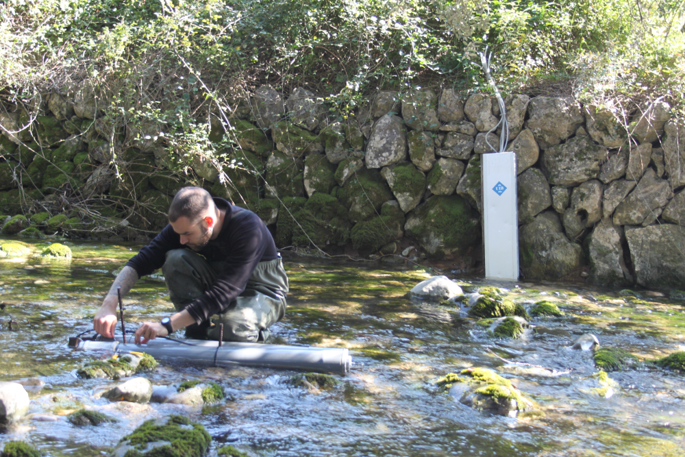
Assessing hydrological and
sediment connectivity in contrasting Mediterranean catchments. Impacts of Global Change.
Medhycon-1 project intends to investigate
changing patterns of hydrological and sediment connectivity induced by climate and land
use changes in Mediterranean catchments by using a sediment budget assembled with
several methods when applied to likely scenarios of global change. The SWAT model,
previously validated with the sediment budgets, may also be used to anticipate the
catchment response to these changes. Research will be focused on three catchments in a
decreasing a priori range of connectivity and increasing size: the small
Vallcebre catchment (4 km2) in the South-Eastern Pyrenees, the Sant Miquel
catchment (151 km2) in the Serra de Tramuntana of Mallorca Island, and the Na
Borges catchment (319 km2) in the Central Depression of Mallorca Island. The
objectives of the project are:
To develop a sediment budget as a perceptual model of hydrological and sediment
connectivity by applying a multi-technique approach within the three catchments.
GIS modelling, sediment-tracer techniques and continuous monitoring of water and
sediment fluxes will be used to develop an understanding of catchment response.
To develop further the application of 137Cs fallout radionuclide to
the study of soil traslocation, erosion and sediment tracing. Particular
attention will be addressed to the various sources of uncertainty. Results
obtained from the application of the improved techniques will be used to improve
the perceptual model developed in (1).
To investigate contaminant transfer by water and sediment through the fluvial
system and to assess the impact of such contaminants on the downstream wetlands
of the Mallorcan catchments, giving particular attention to the effects of land
use.
To apply the SWAT model for continuous simulation of water, sediment and
associated contaminant fluxes to the study catchments. This model will be
adapted to reflect the perceptual model developed for the study catchments. Once
validated and calibrated the SWAT model will be used to simulate the
hydrological and sediment connectivity under different global change scenarios
(i.e. land use and climate changes) in the two larger catchments.
To implement a Spatial Data Infrastructure (SDI) containing referenced
information resulting from continuous monitoring of river fluxes (i.e. water,
sediment and related contaminants from headwaters to downstream parts),
implemented connectivity models with the different global change scenarios, as
well as all considered data of environmental relevance from these catchments and
related wetlands.
Medhycon-2 (2017-2021)
The Medhycon-2 project moves beyond the
current knowledge on ecogeomorphic response of Mediterranean landscapes to global
change. An effective management and intervention in catchments, it is required a
process-based understanding of connectivity (i.e., as a synthetic approach between
ecology, hydrology and geomorphology) and catchment sensitivity (i.e., the severity of a
reaction to a disturbance, relative to the magnitude of the disturbance force).
Medhycon-2 aims to:
Define new methods to accurately assess catchment transmission sensitivity and
how the catchment scale sediment cascade operates and the extent to which any
compartment is connected (coupled) or disconnected (decoupled) for deriving
quantitative information on the temporal change of surface conditions
(functional connectivity) at a range of spatial scales
To evaluate the feedbacks between biological and geomorphological processes in
Mediterranean catchments by modelling global change scenarios under
non-stationarity conditions to define the best strategies (i.e., indicators) to
recover degraded ecosystems. Research will be focused in a representative
Mediterranean cultural landscape, the Sa Font de la Vila catchment (5
km2, Mallorca)
Medhycon-3 (2022-2026)
The Medhycon-3 project pretends to
substantially advance our understanding of ecogeomorphic processes in Mediterranean
catchments under global change impacts, upscaling hillslope observations to catchments
by combining long-term field data and numerical models at various scales in order to
detect degradation thresholds as an effective tool for proactive and smart catchment
action plans. Medhycon-3 pretends to substantially advance the understanding of
ecogeomorphic processes in Mediterranean catchments under global change impacts in order
to detect degradation thresholds as an effective tool for proactive and smart catchment
action plans:
To define connectivity thresholds of water and sediment fluxes for identifying
locations and times when/where feedbacks between landscape form and function are
particularly most susceptible to land degradation.
To upscale hillslope observations of surface energy fluxes to water and sediment
yields in catchments with ecogeomorphic models at multiple and interacting
temporal and spatial scales. Research will be focused in a representative
Mediterranean cultural landscape, the Sa Font de la Vila catchment (5
km2, Mallorca). It is characterized by afforestation of traditional
agricultural land and the effects of two large wildfires in 1994 and 2013 where
agricultural terraces occupy 37%
of the area.
The former Medhycon (CGL2012-32446) and Medhycon-2 (CGL2017-88200-R) investigated
hydrosedimentary and vegetation patterns and functional hydrological and sediment
connectivity in that catchment using UAVs, LiDAR and hyperspectral images,
high-resolution DTM, sediment connectivity index, fallout radionuclides and continuous
monitoring of water and sediment fluxes, so the
current project will be clearly benefited of the already collected data and
instrumentation. The project will combine field-based, artificial inteligence,
remote-sense and modelling techniques.
Inunsab
Early Warning Service for
Flood Risks in the Balearic Islands
The University of the Balearic Islands
implemented in different phases since 2004 a hydrometric network of automated
measurement stations.In this way, a continuous and precise record has been obtained
following the standards of international hydrometric networks. The constant review and
adequate maintenance in the field has allowed hydrometric data to be obtained that
rigorously support surface hydrology research in Mediterranean drainage basins and the
generation of a better knowledge of the behavior of surface hydrology on the island of
Mallorca.It must be borne in mind that the historical records of surface hydrology are
considerations of utmost importance in hydrological planning, flood risks and the
sustainability of other ecosystems.
Thus, the EU Water Framework Directive (2000)
requires the application of hydrological planning cycles in which the robustness and
reliability of the data series generated by the hydrometric networks are fundamental for
the implementation of Flood Risk Plans. However, based on this existing infrastructure
described, the MEDhyCON group intends to create the network of early warning stations by
introducing the ability to communicate data in real time. In this sense, they want to
join forces by taking advantage of the IoTIB platform as a means of communication and
achieve a modern and necessary infrastructure in the Balearic Islands. The main
objectives are to develop:
Hydrological models in real time, in order to simulate potential hydrological
events based on the information obtained through the monitoring of the
hydrometric network
A friendly graphical and cartographic interface (Web; Geoportal HydroMED) of the
monitoring system that allows the consultation of observations in real time and
the visualization of the results of the hydrological models developed as an
early warning system
Infloodmed
Integral flood risk
management in small Mediterranean catchments: monitoring and protocols development for
building resilient territories.
The INFLOODMED project pretends to
substantially advance our understanding of flood risk in small Mediterranean catchments
under climate change impacts, implementing continuous adaptation solutions assessing
current and future vulnerability in flood-prone areas. A hydrological, meteorological,
and territorial long-term monitoring solution will be combined with numerical models at
various scales in order to detect vulnerability thresholds by assessing
sociohydrological feedbaks as an effective tool for proactive and smart Civil Protection
action plans at local scale. The implementation of innovative, open-access and
open-source technologies at the local level will be performed in collaboration with
local/national stakeholders, to evaluate how nature-based solutions of the studied river
catchments (mostly ephemeral rivers) for a better and continuous assessment of the flood
risk. Research will be focused on the Central Mediterranean Region of Spain, i.e.
Alicante, Murcia, and Balearic Islands; which clearly illustrates the transformation of
the economy, society, and environment with an exponential urban expansion, intensive
agriculture, and tourist settlements. The INFLOODMED take advantage of previous Spanish
and European projects and the current
INUNSAB Project designed to establish flood risk
early-warning system in the Balearic Islands which explicitly include the on-time and
continuous discharge monitoring at the headwater parts of small Mediterranean catchments
with the most significant flood hazard. The project will combine ground-sense,
field-based, openaccess
territorial geodatabases and modelling techniques.
VULNER-ISLAND
Evaluation of vulnerability to natural hazards on the island of Mallorca.
The main objective of the project is to develop an integrated conceptual framework of
vulnerability to natural hazards on the island of Mallorca. To this end, a study will be
carried out on the physical vulnerability to natural hazards of different territorial
components: population, critical infrastructure, buildings, land use, ecosystems and tourism
activities. In addition, social vulnerability and its components will be analyzed.
Finally, a set of indicators of the island's vulnerability to natural hazards will be
developed. The study
alsa indudes the development of specific vulnerability monitoring and analysis tools based
on the use of geotechnologies, an analysis of future vulnerability scenarios based on
changes in land use will be carried out, as well as the mapping of hydrological connectivity
to identify areas of sediment concentration to facilitate the rescue of victims after
flooding episodes.
The research will include the development of tools to visualize the
results, such as map viewers and a vulnerability dashboard. In addition, a model for the
dynamic calculation of flood vulnerability will be developed based on information provided
by an early warning system developed within the research group in which the project is
carried out.
The results of the work will represent a significant conceptual and methodological advance
in the scientific field of risk and will provide a transfer tool of unique relevance for
emergency services at the island and municipal levels.
The ultimate goal is to reduce the vulnerability of the island territory to natural hazards
and
to promote the construction of resilient territories based on scientific knowledge of risks
and vulnerabilities. The project Will be carried out over a four-year period by an
interdisciplinary team of geographers, economists and industrial engineers, who will
contribute their knowledge to the joint analysis of natural hazards.
The impacts of climate change - including an
increase
in
prolonged periods of heavy downpours, extreme precipitation rates and river overflows-
are
already
affecting communities, economies, cultural heritage and public health across Europe. The
recent
socioeconomic and environmental impacts of extreme flooding in Ireland, the UK, and
central
Europe
are testimony to the disastrous impacts that such future hazards are likely to pose.
Managing
inundation risk requires prevention measures in close cooperation with Civil protection
Authorities.
To that end, TRIBUTE aims to help Europe-wide national, regional and local CP
authorities answer
the
following vital question in case offlooding: "Should I initiate an evacuation and how
long do I
have
to evacuate safely?". The aswer to the above question is unique per selected area, as
not all
sites
are equally prone to flooding. Having an evacuation plan in place before a flood occurs
can help
avoid confusion as well as prevent injuries and damages. One technique used for
assessing the
time
that an evacuation should be recommended is the so-called "trigger buffer". An
evacuation
trigger
buffer is a pre-established boundary that circumscribes an area in such a way that when
floodwaters
(incl. waters, sediment, contaminated waters and pollution) coming from any direction
cross the
buffer, an evacuation is recomended.
TRIBUTE software tool that will be delivered as a web
service and as a mobile application, will be fed with current estimates of downpour
hazards from
satellites and information of the vulnerability and coping capacity for the threatened
site. The
service will have a pan-European coverage and will be tested extensively in the three
pilot
areas
with different characteristics, including cross-border and multi-threat. TRIBUTE has
rich
training,
dissemination and explotation activities to promote the concept to stakeholders.
Erosion and sediment transport processes in The Middle Atlas (Morocco)
In a context of climate change and
agricultural
practices, increasing population and water needs, together with a better understanding
of the
variability of solid erosion based on developments and land use is essential for
application of
more
effective policies towards reducing land degradation and thus to better meet the
objective of
sustainable development. The dam Bin El Ouidane is a strategic dam for Morocco; it helps
in
maintaining national food security as it ensures the irrigation of large irrigated area
in
Morocco
(69,400 ha), potable water supply for major cities of the region and the production of
hydroelectric
power. The Béni Mellal-Khnifra region is an agricultural region. Its economy is
largely
based
on agricultural production. The latter is under the control of climatic conditions and
availability
of resources (water and soil). Understanding the dynamics between these different
components,
agricultural resources will be better managed.
The main aim of the project is increasing the scientific
knowledge on hydrology and sediment transport in Bin El Ouidane River basin, applying
spatial
analysis of variables related to the soil erodibility, human / climate / environment
relationships
and links with silting of the dam. Likewise, offering training courses to young
researchers
including PhD and PostDoc students, providing mobility for Moroccan researchers to the
UIB, so
they
can work with scientific equipment available in its laboratories.
 Assessing hydrological and sediment connectivity in contrasting Mediterranean catchments. Impacts of Global Change.
 The Medhycon-2 project moves beyond the current knowledge on ecogeomorphic response of Mediterranean landscapes to global change. An effective management and intervention in catchments, it is required a process-based understanding of connectivity (i.e., as a synthetic approach between ecology, hydrology and geomorphology) and catchment sensitivity (i.e., the severity of a reaction to a disturbance, relative to the magnitude of the disturbance force). Medhycon-2 aims to:
 The Medhycon-3 project pretends to substantially advance our understanding of ecogeomorphic processes in Mediterranean catchments under global change impacts, upscaling hillslope observations to catchments by combining long-term field data and numerical models at various scales in order to detect degradation thresholds as an effective tool for proactive and smart catchment action plans. Medhycon-3 pretends to substantially advance the understanding of ecogeomorphic processes in Mediterranean catchments under global change impacts in order to detect degradation thresholds as an effective tool for proactive and smart catchment action plans:
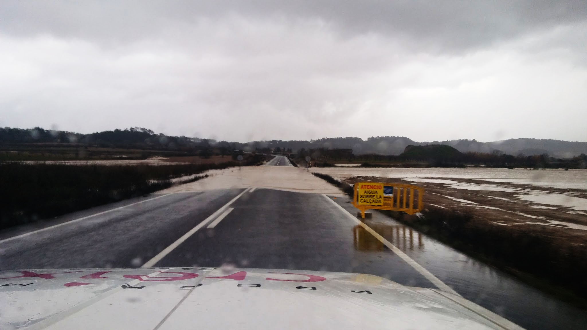 Early Warning Service for Flood Risks in the Balearic Islands
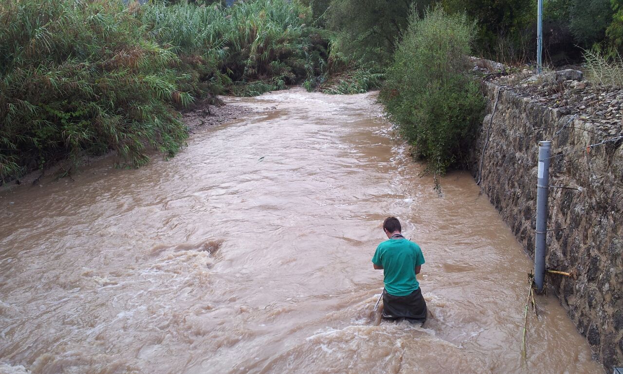 Integral flood risk management in small Mediterranean catchments: monitoring and protocols development for building resilient territories.
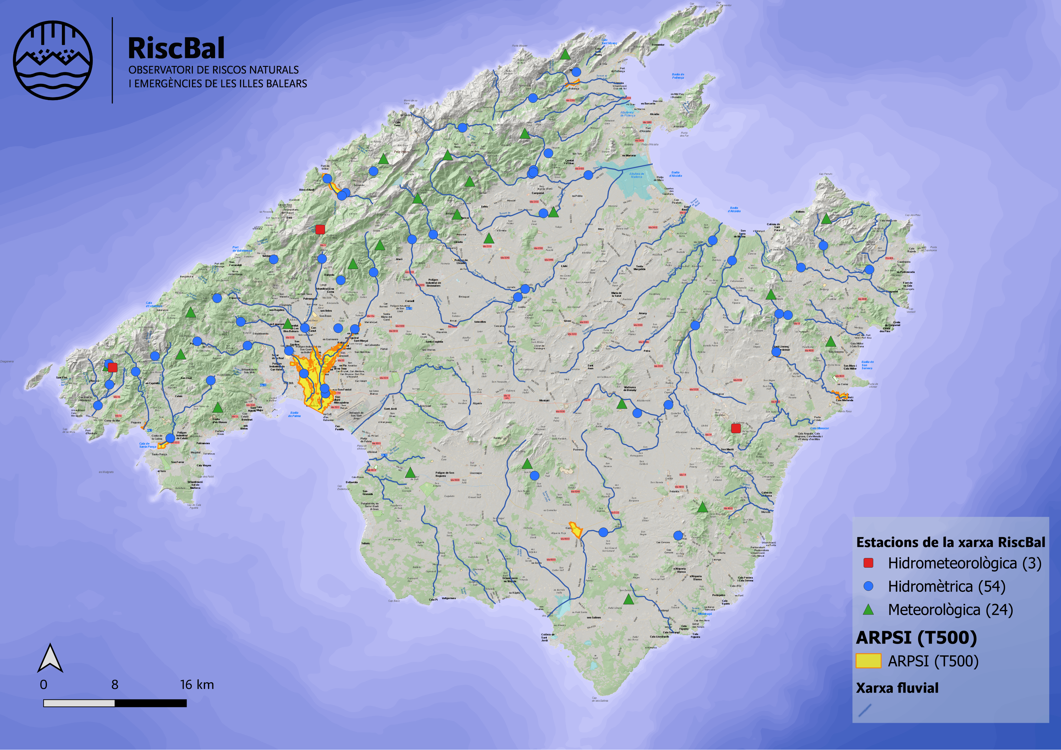 Evaluation of vulnerability to natural hazards on the island of Mallorca.
 The impacts of climate change - including an increase in prolonged periods of heavy downpours, extreme precipitation rates and river overflows- are already affecting communities, economies, cultural heritage and public health across Europe. The recent socioeconomic and environmental impacts of extreme flooding in Ireland, the UK, and central Europe are testimony to the disastrous impacts that such future hazards are likely to pose. Managing inundation risk requires prevention measures in close cooperation with Civil protection Authorities. To that end, TRIBUTE aims to help Europe-wide national, regional and local CP authorities answer the following vital question in case offlooding: "Should I initiate an evacuation and how long do I have to evacuate safely?". The aswer to the above question is unique per selected area, as not all sites are equally prone to flooding. Having an evacuation plan in place before a flood occurs can help avoid confusion as well as prevent injuries and damages. One technique used for assessing the time that an evacuation should be recommended is the so-called "trigger buffer". An evacuation trigger buffer is a pre-established boundary that circumscribes an area in such a way that when floodwaters (incl. waters, sediment, contaminated waters and pollution) coming from any direction cross the buffer, an evacuation is recomended.
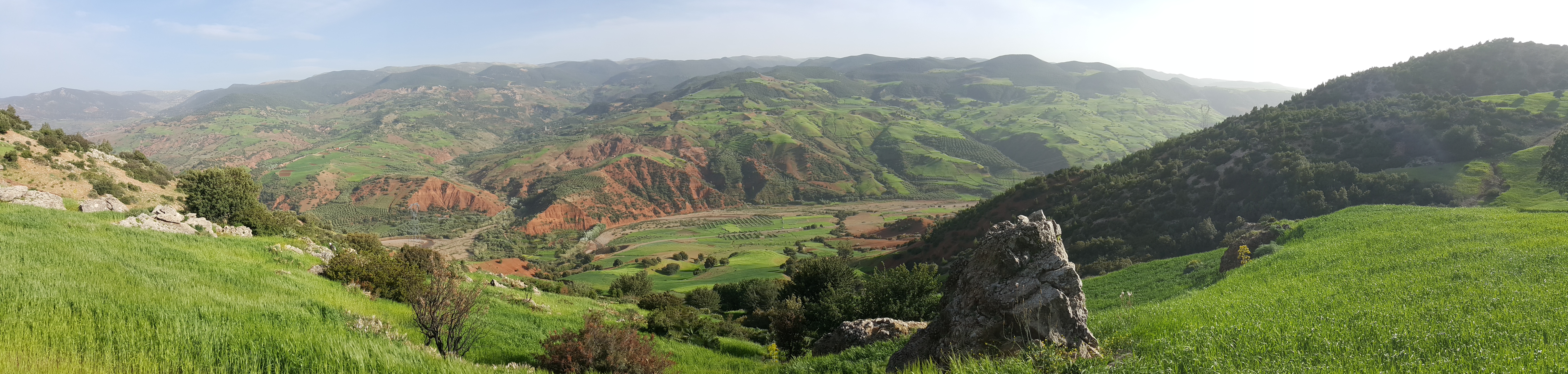 In a context of climate change and agricultural practices, increasing population and water needs, together with a better understanding of the variability of solid erosion based on developments and land use is essential for application of more effective policies towards reducing land degradation and thus to better meet the objective of sustainable development. The dam Bin El Ouidane is a strategic dam for Morocco; it helps in maintaining national food security as it ensures the irrigation of large irrigated area in Morocco (69,400 ha), potable water supply for major cities of the region and the production of hydroelectric power. The Béni Mellal-Khnifra region is an agricultural region. Its economy is largely based on agricultural production. The latter is under the control of climatic conditions and availability of resources (water and soil). Understanding the dynamics between these different components, agricultural resources will be better managed.